Adios, Crystal River, FL....errr I mean Boston

19 foot waves at buoy 42097 (Pulley Ridge, FL), appx 75NM ESE of the center of Idalia.

Waves on top of storm surge are a big problem.

 
TWC guy keeps showing radar and satellite loops and claiming "It looks like the eye is forming".

He's said it multiple times. derp

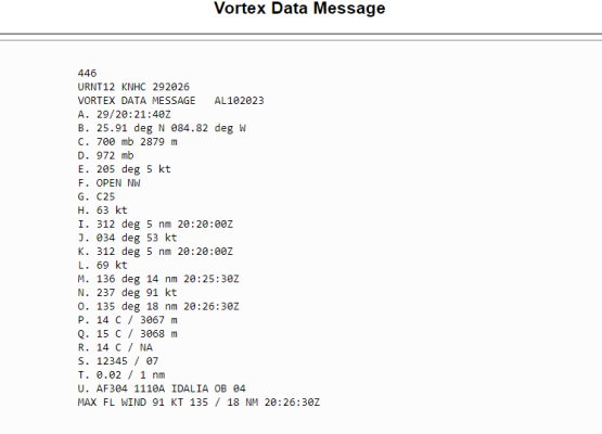
The got damned eye formed hours ago according to the last recon Vortex Data Message that had it as "Closed". That means it had a 360° eyewall.

I think what he's trying to say is the eye is trying to clear out.

In a healthy hurricane you should be able see the ocean/gulf, etc. down through the eye hole. The eye should be void of clouds.
 
Idalia's eye is struggling to clear out on satellite and radar.

Likely because of the PV streamer (yellow) infusing the system. That's UL dry air and a bit of shear.

She'll get past it, but it's good news for delaying intensification.

View attachment 106271

Got some dry air (blue) trying to make it's way into the core at the end of this loop. If it's successful it'll disrupt the eyewall somewhat.

The next Vortex Data Message could be interesting.


Latest recon Vortex Data Message shows the eyewall opened up to the NW.
This is good news as it's delaying intensification considerably.

1693342812127.png
 
Storming Tropical Storm GIF by Storyful
Climate Change California GIF by INTO ACTION
 
As of the 5 pm advisory it’s a Cat 2. 100 mph max sustained winds.
 
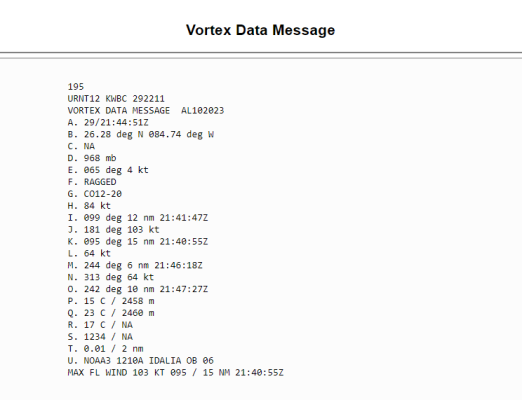
AF released another Vortex Data Message.

The eye is "RAGGED" (F) and "Concentric" at 12 - 20 NM wide (G).

This is not a healthy cane ATM.

Maximum surface winds (L) are 64 kt's outbound, which is just 74 mph. i.e. Barely a Cat 1.
Inbound surface winds (H) were 84 kts, which is 96 mph. i.e. Barely a Cat 2.

There's still time for it to get reorganized, but that PV Stream really fucked with it.

1693347858612.png
 
Last edited:
AF released another Vortex Data Message.

The eye is "RAGGED" (F) and "Concentric" at 12 - 20 NM wide (G).

This is not a healthy cane ATM.

Maximum surface winds (L) are 64 kt's outbound, which is just 74 mph. i.e. Barely a Cat 1.
Inbound surface winds (H) were 84 kts, which is 96 mph. i.e. Barely a Cat 2.

There's still time for it to get reorganized, but that PV Stream really fucked with it.

View attachment 106295

^^ My bad. That was NOAA's P3 (Miss Piggy) flight. ^^
 
Concentric eyewall cycles naturally occur.
Duh!!

Concentric Eyewall Cycles = Eyewall Replacement Cycles, dufus.

Healthy hurricanes certainly undergo "Eyewall Replacement Cycles". A smaller eyewall forms inside the original one, then the original 'outer' eyewall collapses leaving just the new one. That's not what's happening here.

In weak or weakening storms. A ragged, asymmetrical eye means it's having difficulty organizing and strengthening.

This has never really been a healthy cane. It's never even cleared the cloud cover from it's eye. It's intensification has suffered from dry air infusion and windshear. It looked like it was getting there on satellite and radar, but it has yet to materialized.

It's still got time to get more organized and strengthen (12 hrs). We shall see.
I do know if I were in the cone and within a couple miles of the coast I'd be evacuating from the storm surge.
 
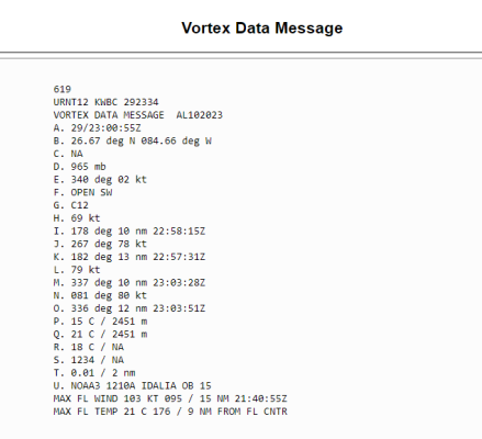
Air Force's second recon flight appx 6pm (CT).

Eyewall: Open SW
Circular 12 NM diameter

Max inbound surface winds: 79 mph
Max outbound surface winds: 90 mph

Pressure dropped to 965 mb
That's down from 972 mb in their earlier flight.

Barometric pressure precedes wind speed, so I'd expect those windspeeds to eventually increase.


1693354264452.png
 
Back
Top