Install the app
How to install the app on iOS
Follow along with the video below to see how to install our site as a web app on your home screen.
Note: This feature may not be available in some browsers.
You are using an out of date browser. It may not display this or other websites correctly.
You should upgrade or use an alternative browser.
You should upgrade or use an alternative browser.
Elsa
- Thread starter DraftNerd
- Start date
- Joined
- Aug 17, 2020
- Posts
- 13,207
- Reaction score
- 16,658
- Bookie:
- $ 1,354.00

Terrifying here. The wind is like 2 mph and it has been sprinkling.
A client called from Buffalo NY with concern because she said there's a big, red-puplish blob approaching Fort Myers. She was quite surprised with my reality report.
A client called from Buffalo NY with concern because she said there's a big, red-puplish blob approaching Fort Myers. She was quite surprised with my reality report.
- Joined
- Aug 30, 2020
- Posts
- 4,764
- Reaction score
- 6,667
- Bookie:
- $ 1,136.00


I'm watching local live update right now.. possible cat 1 about 80 miles from me.. it's spitting rain off and on here atm. I'm trying to get these FTLs out of Fl today.. we may shut down my work tomorrow.. can't run the equipment in high winds
Last edited:
- Joined
- Aug 17, 2020
- Posts
- 13,207
- Reaction score
- 16,658
- Bookie:
- $ 1,354.00
The winds have really increased. We're probably blowing near 10 to 15 mph right now. AND, it's raining too.
However, you can see rotation in the clouds now. So, she'll increase in intensity before landing up north somewhere.
However, you can see rotation in the clouds now. So, she'll increase in intensity before landing up north somewhere.


Yep. I don’t watch any of those bastards anymore. Local news if it’s something imminently bad for my locale, otherwise just go to the sources like NHC.Not worried too much, we'll get heavy winds and rain, maybe some surge around the coast, but the media outside of FL are making it sound like the end of the world, it's not. I stay away from The Weather Channel, CNN etc, they always big everything up for ratings. Let's not forget video of Seidel during Florence where he got caught sensationalizing.
I didn’t realize you were down this way

I should have noticed. Who is a Rays fan out of Florida?
I think it will be right on where you called it yesterdayIt's going to hit just south of Cedar Key if the low out west keeps snailing along and Elsa slows down any more.. was at 14mph now at 12..

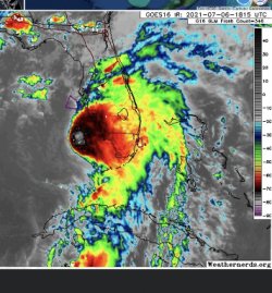
I don’t know if there will be much strengthening at all. She’s got no left side, and was clearing pulling dry air up into the core earlier. Seems the core is closed in the attached pic. But that’s still a choke going on.The winds have really increased. We're probably blowing near 10 to 15 mph right now. AND, it's raining too.
However, you can see rotation in the clouds now. So, she'll increase in intensity before landing up north somewhere.
Attachments
- Joined
- Aug 17, 2020
- Posts
- 13,207
- Reaction score
- 16,658
- Bookie:
- $ 1,354.00
Well, here on the right side I can say the storm is accelerating a bit. The winds are 40s during squalls with driving rain, with intermittent calm between the waves. It's just as you'd expect. The lines on the boat are taught but not stretched.I don’t know if there will be much strengthening at all. She’s got no left side, and was clearing pulling dry air up into the core earlier. Seems the core is closed in the attached pic. But that’s still a choke going on.
By the time it gets to Tampa, they'll see gusts of 60 or so...doubt it'll get close to a Cat 1.
- Joined
- Aug 17, 2020
- Posts
- 13,207
- Reaction score
- 16,658
- Bookie:
- $ 1,354.00
The wind is still from the SE, but the storm is even and slightly north of me now and the wind should be from the South. Such a weird storm.
This is facing South and the East wind knocks em down flat. This should turn big in 20 minutes as the wind switches. Then, we'll get a high tide tonight from the SW wind as it heads away North.

 islandinnsanibel.com

 www.casaybelresort.com
This is facing South and the East wind knocks em down flat. This should turn big in 20 minutes as the wind switches. Then, we'll get a high tide tonight from the SW wind as it heads away North.
🎥🌴Sanibel Island LIVE Beach Cam🐬☀️
We are live! Join us from anywhere in the world on our high-definition, Sanibel Island beach cam stream via the link below. Take the time to soak up the sun and seashells as we continue to restore this beautiful paradise, Sanibel Island! ⛱️☀️🐚
Beach Cam - Casa Ybel Resort | Sanibel Island Resorts | Official Site
www.casaybelresort.com
It makes a Cat 1 before Tampa, barely, but the worse stays off shore. Surge flooding and 55-60 gusts there IMO.Well, here on the right side I can say the storm is accelerating a bit. The winds are 40s during squalls with driving rain, with intermittent calm between the waves. It's just as you'd expect. The lines on the boat are taught but not stretched.
By the time it gets to Tampa, they'll see gusts of 60 or so...doubt it'll get close to a Cat 1.
- Joined
- Aug 17, 2020
- Posts
- 13,207
- Reaction score
- 16,658
- Bookie:
- $ 1,354.00
We're getting slammed in the tail. The storm was nothing compared to this. 50+ winds and 12 inches of rain already.
- Joined
- Aug 30, 2020
- Posts
- 4,764
- Reaction score
- 6,667
- Bookie:
- $ 1,136.00
So let me just tell you how much fun it is to be awoken at 4:21 am from a pretty good sleep by your weather radio, phone text and a phone call telling you to take cover that a doppler indicated tornado was less than a mile from your house rapidly moving toward you ... it's not.. just saying


20 years ago, there were no alerts like that... A tornado would just wipe you off the earth with no/little warning... I'll take "losing an hour or two of sleep every once in a while from an alert" over "having my family members pick fragments of my corpse out of a tree six blocks away".So let me just tell you how much fun it is to be awoken at 4:21 am from a pretty good sleep by your weather radio, phone text and a phone call telling you to take cover that a doppler indicated tornado was less than a mile from your house rapidly moving toward you ... it's not.. just saying
- Joined
- Aug 30, 2020
- Posts
- 4,764
- Reaction score
- 6,667
- Bookie:
- $ 1,136.00
I have had a weather radio over 20 years just fyi.. it's still never fun when they go off in the middle of the night..20 years ago, there were no alerts like that... A tornado would just wipe you off the earth with no/little warning... I'll take "losing an hour or two of sleep every once in a while from an alert" over "having my family members pick fragments of my corpse out of a tree six blocks away".
Well….I have to give this storm credit. And modeling too. Once we got close enough for models to be relevant and they all started lining up they were pretty spot on with track and intensity.
She didn’t stand a chance in the gulf ultimately as she kept sucking in dry air to the west. But, here’s the credit, she didn’t stop trying. That center never got any kind of good formation (saw an eye briefly appear and then disintegrate yesterday/last night). But, that center has kept on firing.
I’m seeing a lot on SW FL today about localized flooding. The whole impact of the storm is to the east only. The tail of this storm is turning out to be the ugliest part to deal with.
But, it’s just rain and flooding and not worse. Now this will pass and we will keep moving towards Aug-Oct and what awaits us there.
- Joined
- Aug 30, 2020
- Posts
- 4,764
- Reaction score
- 6,667
- Bookie:
- $ 1,136.00
Well….I have to give this storm credit. And modeling too. Once we got close enough for models to be relevant and they all started lining up they were pretty spot on with track and intensity.
She didn’t stand a chance in the gulf ultimately as she kept sucking in dry air to the west. But, here’s the credit, she didn’t stop trying. That center never got any kind of good formation (saw an eye briefly appear and then disintegrate yesterday/last night). But, that center has kept on firing.
I’m seeing a lot on SW FL today about localized flooding. The whole impact of the storm is to the east only. The tail of this storm is turning out to be the ugliest part to deal with.
But, it’s just rain and flooding and not worse. Now this will pass and we will keep moving towards Aug-Oct and what awaits us there.
My Daughter's birthday 9/10.. height of hurricane season.. mine 14 days later
- Joined
- Aug 17, 2020
- Posts
- 41,467
- Reaction score
- 47,162
- Bookie:
- $ 122,000.00
- Location
- still exiled in Illinois


Glad y'all seem to have made it.
Glad y'all seem to have made it.

- Joined
- Aug 17, 2020
- Posts
- 41,467
- Reaction score
- 47,162
- Bookie:
- $ 122,000.00
- Location
- still exiled in Illinois
Nevermind

I'm on Isle of Palms and got a couple of Tornado warnings at about 2:30am and 3:15am last night. The lightening was popping frequently and the wind picked up. But overall we didn't lose power or had any damage to property.